GIS Datasets – Supplemental

Revised map for the 2012 NAWMP
Revised map for the 2012 NAWMP, depicting general areas of high continental significance to North American ducks, geese, and swans. Shaded regions have highest relative importance to individual species or total continental waterfowl populations during the breeding, migration, and or winter periods (NAWMP 2012a). The JV region was recognized for its importance to waterfowl in the 2012 NAWMP, particularly for migration habitat provided to ducks, geese, and swans (Soulliere et al. 2012). Consistently important waterfowl stop-over areas include the lower Great Lakes and connecting waters (Saginaw Bay, Lake St. Clair, and western Lake Erie) and the floodplains of the Illinois and Mississippi Rivers.

Counties and BCRs within Region 3
Counties and BCRs within Region 3 of the U.S. Fish and Wildlife Service and the Upper Mississippi / Great Lakes Joint Venture Region.

Land Ownership
Location of federal, state, or other conservation lands in the Upper Mississippi River and Great Lakes Joint Venture Region. The Other ownership category includes private land with perpetual/long-term conservation easements (e.g., Wetlands Reserve Program), conservancy land, and county, township, and city-owned land. Note: Some large blocks encompass areas of acquisition interest rather than full ownership.

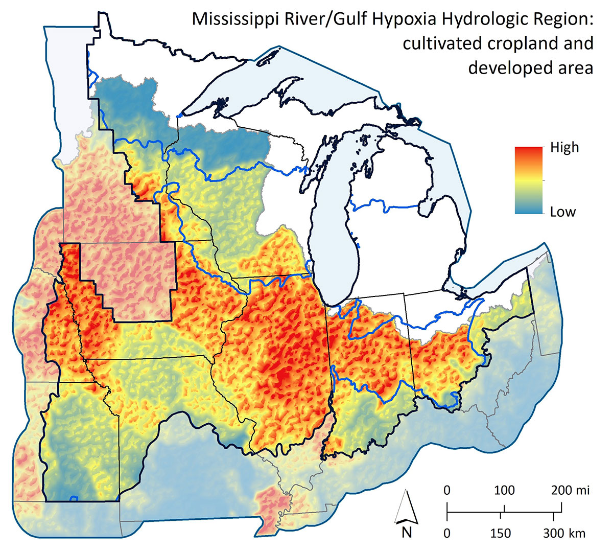
Mississippi River/Gulf Hypoxia Hydrologic Region
Sub-basins ranked by greatest coverage of cultivated cropland and development, contributing to Gulf hypoxia. Data source: NLCD (2011) and National Agricultural Statistics Service (NASS 2016).

Great Lakes Hyrdrologic Region
Impairments to coastal areas of the Great Lakes. Data source: NLCD (2011) and National Agricultural Statistics Service (NASS 2016).

Human Population
Number of people per block. Data source: U.S. census (2010)

Human Population Hotspots
Density and distribution of human populations. Data source: U.S. census (2010)

Conservation Opportunities Associated with Human Populations
Geographic distribution of human-populated areas expected to receive greatest use by outdoor recreationists if accessible waterfowl habitats are available. Data source: U.S. census (2010)

Poorly Drained Soils
Locations (in green) exhibiting poorly drained to somewhat poorly drained soils. Local-scale soils data is available from U.S. Department of Agriculture (www.soils.usda.gov/survey).

Poorly Drained Soils Where Current Land Use Is Cultivated Cropland
Locations (in green) exhibiting poorly drained to somewhat poorly drained soils where current land use is cultivated cropland. Local-scale soils data is available from U.S. Department of Agriculture (www.soils.usda.gov/survey).

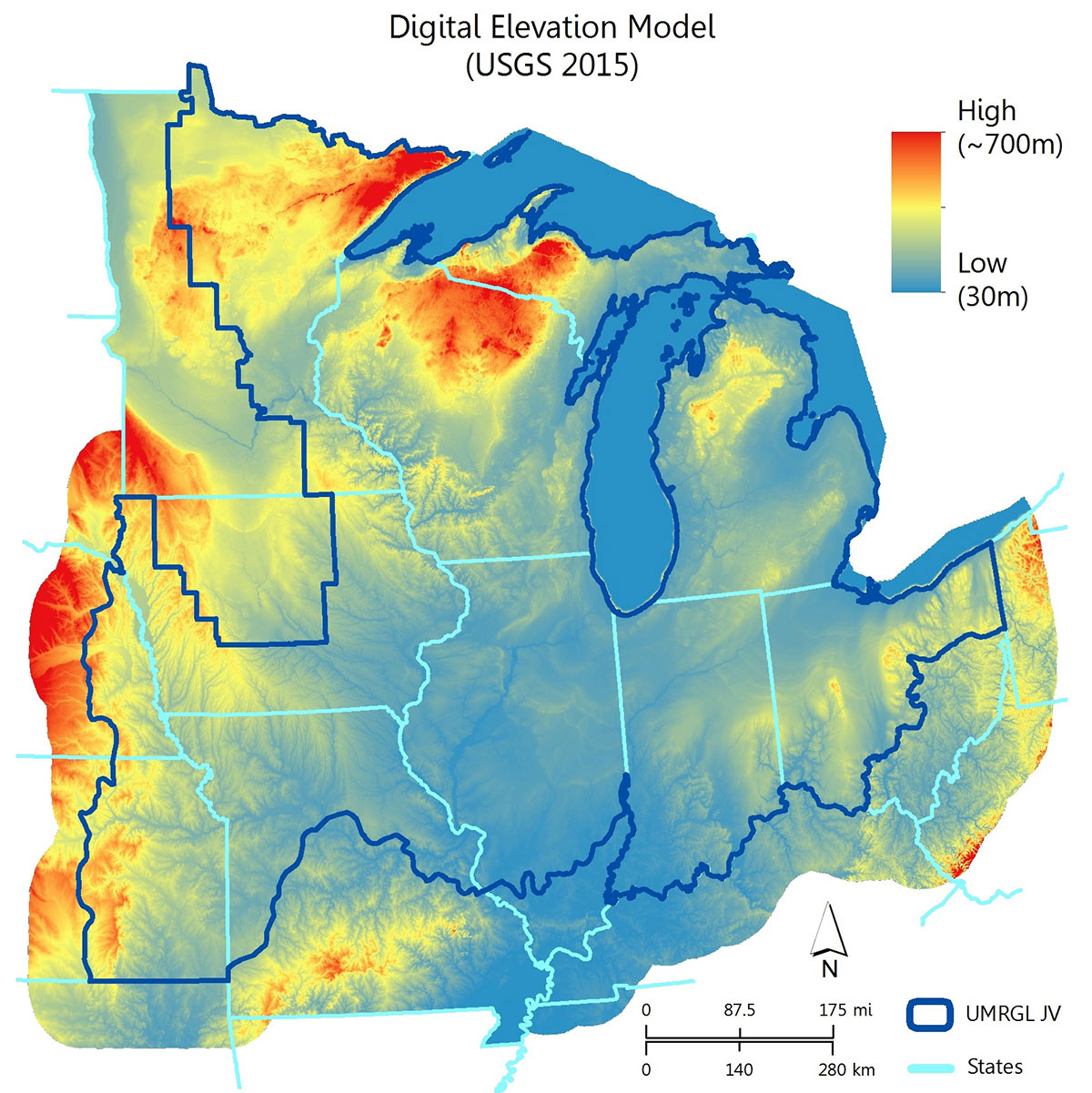
Digital Elevation Model
Digital Elevation Model (DEM) for the Upper Mississippi / Great Lakes Region Joint Venture. Data source: USGS (2015).

Cumulative Restoration and Enhancement for Wetland and Uplands
Cumulative restoration and enhancement (2007 – 2017) for wetlands and uplands combined, within five Bird Conservation Regions of the Upper Mississippi / Great Lakes Region Joint Venture.

Cumulative Restoration and Enhancement for Wetlands Only
Cumulative restoration and enhancement (2007 – 2017) for wetlands only, within five Bird Conservation Regions of the Upper Mississippi / Great Lakes Region Joint Venture.

Cumulative Restoration and Enhancement for Uplands Only
Cumulative restoration and enhancement (2007 – 2017) for uplands only, within five Bird Conservation Regions of the Upper Mississippi / Great Lakes Region Joint Venture.


